Any user of Dublin city will at some point have noticed, underfoot, the river Liffey’s many bridges. But have you ever considered the significance of the bridges we use every day in the city? A new City Council website aims to showcase the historical significance of Dublin’s city centre bridges.
The site, bridgesofdublin.ie, offers videos, pictures, biographies and timelines of our most famous bridges. It details facts, like the fact Mellows Bridge – situated near Smithfield – is Dublin’s oldest, built in 1768 or that Dublin has two O’Connell bridges – one of which is located in Stephen’s Green.
The site gives interesting detail about each of the city’s bridges: did you know that O’Connell Bridge spans 45 metres? Or that an estimated 30,000 pedestrians cross the Ha’penny Bridge a day? The site has over 900 photographs and contains over 3,000 words, not to mention historical maps and statistics.
“With a bridge history extending back hundreds of years, the team working on the Bridges of Dublin website did a tremendous job,” said Michael Philips the Director of Traffic at the City Council and City Engineer. “Compiling and editing vast quantities of information into what is an easy-to-use, responsive website which will prove to be a fantastic source of information for anyone interested in bridges and Dublin’s history.”
“Some of the images, like the building of the West Link Bridge, are quite striking,” said Peter Dee, a Senior Staff Officer at Dublin City Council who worked obtaining images for the site. “We were looking for events, things happening on the bridges, and we got a lot of help from RTÉ, it was fascinating.”
The site only details the 23 bridges throughout the city and the odd bridge in a cosmopolitan area such as Lucan and Chapelizod. The East Link Bridge, which connects Ringsend and Dublin 4 to the city, is the only bridge in the Dublin 4 area that gets a mention.
What’s the historical significance of bridges in Dublin 4?
“Bridges have been enormously important in the development of both Ballsbridge and the wider area of south Dublin,” said Hugh Oram, a local historian and author of Ballsbridge Then and Now.
When bridges started to pop up in and around Dublin 4 it gave a boost to local businesses, allowing more people to fill the pubs and buy the produce. The Railway Bridge, situated near what is now the Aviva Stadium, served as a development link for commuters as far out as Greystones. This particular station didn’t open until 1870 with another station opening in Sydney Parade in 1835.
As the years went on, other bridges began to come on board, like the Grand Canal Dock Bridge and the Samuel Beckett, which provided a new lifeline for an expanding Southside.
“A lot of Dublin 4 bridges are just slightly outside the Ballsbridge area, like the one at Londonbridge Road and further upstream, at Donnybrook. Baggot Street Bridge marks the boundary of Ballsbridge in that particular part of the city, likewise Leeson Street Bridge,” said Hugh.
The new Council website hopes to expand to include other areas, including many parts of the city where bridges have been overlooked. The Council didn’t speculate on whether this will include Dublin 4. In November, the site won a Best Government and Local Government Website award at the annual Web Awards.
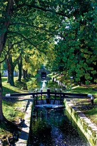
Pictured left: A lock on the Grand Canal.
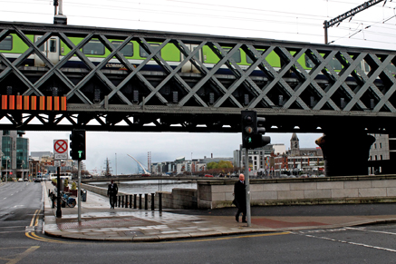
Below: River Liffey viewed from Butt Bridge.
By Liam Cahill