Concerns on the issuing of flood cover within house insurance policies have arisen recently for Dublin 4 residents in relation to river and sea flooding.
Insurance companies have used a system of geocoding risk profiling based on topography and flood event histories around Ireland. Since the River Dodder flooding in 2010 in particular, insurance companies have revoked flood insurance elements in householders’ policies which many residents may not be aware about at present.
Terry Pierce of Stability Financial, Sandymount, who has been made aware of his clients’ difficulties stated that “companies are using an old coding system, it’s quite outdated in the actual technology it uses.”
This is echoed by Simon Richards of a new insurance agency, FootPrint Underwriting, Merrion. Richards has worked in the insurance industry for numerous years and is aware of the logic behind the geocoding system.
“These flood models are created by actuaries who have never been out to the houses,” states Richards. “The models use flood water mapping, which can often be incorrect; in some cases the models have water flowing up a hill!” Richards states that, “more needs to be done with local knowledge in the area,” including the use of loss adjustors or assessors who would know the area very well.
Local TD Kevin Humphreys has been working on the issue for a number of years, including challenging the insurance industry through the Oireachtas Joint Committee on Environment, Culture and the Gaeltacht. He has been liaising with the insurance industry about this issue recently and has been one of the leading figures in recently acquiring a Memorandum of Understanding from Insurance Federation Ireland reinstating flood cover for local residents in certain areas of Dublin 4.
In particular, those who live along the Dodder, where flood defence works have been carried out in recent years up to Londonbridge, should find they can now get flood cover reinstated in their insurance policy. Humphreys stated that householders should be, “seeing results from the Memorandum of Understanding” and should make sure that flood cover is now included. In addition, “I urge people to read their policies, as many householders may not be aware that flood cover had been rescinded from their house insurance in recent years.” Richards also warned about this, as insurance companies may send out a new policy document several pages long which householders may not read through thoroughly, and the flood cover may be omitted.
Flood issues for the area arise due to the incidents of flooding from both tidal surging and river overflows. With regard to tidal flooding, Dublin City Council engineer Gerard O’Connell has issued a letter since 2011 mentioning the flood protection works over the section of the Dodder Estuary from Ringsend Bridge to Londonbridge in particular. This includes protection on the western side, such as South Lotts Rd and Barrow St.
Pierce, of Stability Financial states that, “we don’t think that the whole of Sandymount and areas of D4 should be covered under the Flood Risk category. So what we are doing at the present time is dealing with each case separately and working with the insurance companies to come to a fair agreement. A house that has never been flooded in 100 years and is 500 metres from the sea shouldn’t be refused flood cover.” He also adds that, “I think it is something that people need to be aware of – when their next household renewal is sent out, read the fine print and make sure that your home is covered against flood damage.”
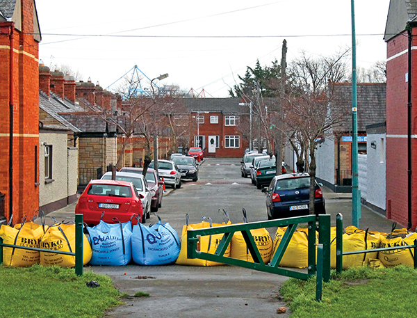
Properties on the Sandymount coastal area are protected in a practical way by Dublin City Council Tidal Surge monitoring system, which takes readings from the Irish Sea to warn authorities of tidal surges that are significant enough for flood risk. When such a risk presents itself, DCC use preventative action such as flood defences on high risk roads leading off Strand Road, such as Marine Drive, for example. Traffic is also diverted and gates are closed on the Dodder.
Notifications are put out through the DCC website, Facebook and Twitter accounts, as well as radio announcements.
Concerns on the issuing of flood cover within house insurance policies have arisen recently for Dublin 4 residents in relation to river and sea flooding.
Insurance companies have used a system of geocoding risk profiling based on topography and flood event histories around Ireland. Since the River Dodder flooding in 2010 in particular, insurance companies have revoked flood insurance elements in householders’ policies which many residents may not be aware about at present.
Terry Pierce of Stability Financial, Sandymount, who has been made aware of his clients’ difficulties stated that “companies are using an old coding system, it’s quite outdated in the actual technology it uses.”
This is echoed by Simon Richards of a new insurance agency, FootPrint Underwriting, Merrion. Richards has worked in the insurance industry for numerous years and is aware of the logic behind the geocoding system.
“These flood models are created by actuaries who have never been out to the houses,” states Richards. “The models use flood water mapping, which can often be incorrect; in some cases the models have water flowing up a hill!” Richards states that, “more needs to be done with local knowledge in the area,” including the use of loss adjustors or assessors who would know the area very well.
Local TD Kevin Humphreys has been working on the issue for a number of years, including challenging the insurance industry through the Oireachtas Joint Committee on Environment, Culture and the Gaeltacht. He has been liaising with the insurance industry about this issue recently and has been one of the leading figures in recently acquiring a Memorandum of Understanding from Insurance Federation Ireland reinstating flood cover for local residents in certain areas of Dublin 4.
In particular, those who live along the Dodder, where flood defence works have been carried out in recent years up to Londonbridge, should find they can now get flood cover reinstated in their insurance policy. Humphreys stated that householders should be, “seeing results from the Memorandum of Understanding” and should make sure that flood cover is now included. In addition, “I urge people to read their policies, as many householders may not be aware that flood cover had been rescinded from their house insurance in recent years.” Richards also warned about this, as insurance companies may send out a new policy document several pages long which householders may not read through thoroughly, and the flood cover may be omitted.
Flood issues for the area arise due to the incidents of flooding from both tidal surging and river overflows. With regard to tidal flooding, Dublin City Council engineer Gerard O’Connell has issued a letter since 2011 mentioning the flood protection works over the section of the Dodder Estuary from Ringsend Bridge to Londonbridge in particular. This includes protection on the western side, such as South Lotts Rd and Barrow St.
Pierce, of Stability Financial states that, “we don’t think that the whole of Sandymount and areas of D4 should be covered under the Flood Risk category. So what we are doing at the present time is dealing with each case separately and working with the insurance companies to come to a fair agreement. A house that has never been flooded in 100 years and is 500 metres from the sea shouldn’t be refused flood cover.” He also adds that, “I think it is something that people need to be aware of – when their next household renewal is sent out, read the fine print and make sure that your home is covered against flood damage.”
Properties on the Sandymount coastal area are protected in a practical way by Dublin City Council Tidal Surge monitoring system, which takes readings from the Irish Sea to warn authorities of tidal surges that are significant enough for flood risk. When such a risk presents itself, DCC use preventative action such as flood defences on high risk roads leading off Strand Road, such as Marine Drive, for example. Traffic is also diverted and gates are closed on the Dodder.
Notifications are put out through the DCC website, Facebook and Twitter accounts, as well as radio announcements.
By Ferg Hayden