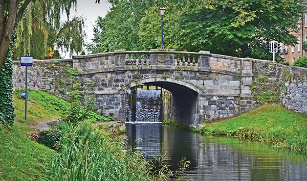
Pictured: Huband Bridge.
To celebrate Heritage Week, NewsFour took to the streets and joined other curious walkers on a guided tour of The Grand Canal. A series of excursions were organised by the Royal Canal Amenity Group, an association set up in 1974 to campaign for the re-opening of Dublin’s other great waterway.
In 2010, their wish was granted, and since then, the group have refocused their efforts on promoting the heritage and recreational potential of both canals.
Tour-guide for the day was amateur historian, Derek Whelan, and we started with a brief look at how the “Grand” came into existence. Back in the 13th century, Dublin was the first modern city to produce a public water supply, with water drawn from the river Poddle.
Around 1721, the reservoir known as the city basin was established near the Guinness storehouse, to serve the burgeoning population as the city had doubled in size in the previous 40 years. It soon became evident that the Poddle alone wouldn’t be sufficient to service the ever-increasing population, and so the Grand Canal project was born.
Not only would the new structure supply the city basin with an alternative water source, it would also allow Guinness to transport barrels of stout to the midlands via barge, and also supply their brewery with the water that it required for the brewing process.
Work started on the main line near Sallins in 1756, and it took twenty years to reach Clondalkin, with plans in place to also build west to the Shannon. The project was not without its complications, and challenges were encountered crossing the Bog of Allen, as well as the River Liffey, where an aqueduct was originally proposed, but never took shape.
The Shannon was eventually reached around 1800, but in the meantime, in 1790 to be exact, work began on a new circular line of the canal, that would take it from Portobello to Ringsend, following the route of the new circular road. The build would finish in 1796 when it reached Ringsend basin, and was funded by local businessmen who wanted access to the considerable traffic and opportunities down at the docks.
Back to the present day and our first port of call was Huband bridge on Percy place, one of the more ornate structures on the route. Bridges at the time were typically named after directors of the canal company and this one is no different. Huband owned the land where the bridge was to go, and wanted an extortionate price. He settled instead for his name on the arch and a fancy motif.
Next we moved to Mount Street bridge, a pretty nondescript, flat construction, famous of course for its part in the 1916 rising. Onwards to Mcquay’s bridge on Grand Canal Street where the new Accenture building sits on the site of the old Dublin Meat Packers factory. Here we look down at the beginning of the canal’s inner basin and its original walls.
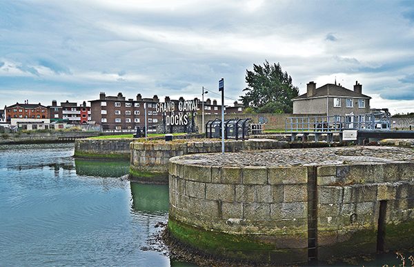
Pictured: The locks at Grand Canal Docks.
Out into the inner basin proper and a stop outside Waterways Ireland, the site of various seed stores in the 1800’s that stored flour and malt. Factories from the time included a sugar distillery that processed sugar cane from the Caribbean, and the old Hammond Lane foundry, where the Lir Theatre now resides.
Looking across at the last bridge on our trip, the McMahon lifting bridge, and the sight of modern high-rise apartments where an old cottage belonging to the bridge operator used to be.
Crossing to the outer basin and a stop outside number nine Hannover Quay, the one house that remains in the area, and home of developer Harry Crosbie.
Images: Kevin O’Gorman.
Moving on past the site of the old Gas Works that used to take in coal from England, past the Irish Raleigh company’s old headquarters that is currently being demolished, and down to the dry docks where ships were once repaired.
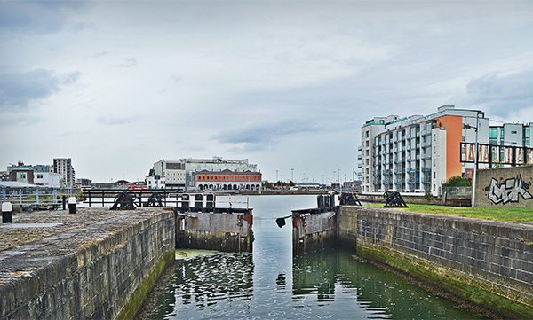
We see the three locks that moved boats from basin to river, each named after dignitaries: Westmoreland, Buckingham and Camden, and an old abandoned ship called the Naomh Eanna, that used to ferry passengers from Galway to the Aran Islands up until the 1980’s.
And so our tour has ended. One last look out to sea and I can’t help thinking, how times have changed.
By Paul O’Rourke