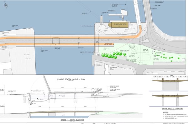
Plans for the new Dodder bridge. Image courtesy Dublin City Council / ROD.
By Alexander Kearney
On the 15th February, Dublin City Council held its first public consultation for the proposed Dodder bridge at Ringsend and Irishtown Community Centre. The venue itself is within a stone’s throw of where the new bridge will span the mouth of the Dodder, separating Sir John Rogerson’s Quay and the northern-most tip of Ringsend. Representatives from the City Council’s roads division and consultant engineers, ROD (Roughan and O’Donovan) provided a broad outline of what to expect.
NewsFour has previously reported on the earliest details to emerge, such as the fact that the bridge would open to river traffic and that it would prioritise public transport. The consultation confirmed that it would carry pedestrians, cyclists, taxis, and public buses, but would exclude private motor cars.
The plans show the patch of land that will be reclaimed to the west of the Tom Clarke Bridge (East Link) to facilitate a control building and a new club house for St Patrick’s Rowing Club. It was further revealed that the bridge would make provision for a Luas extension via tracks and circuit buried beneath its surface. These tracks would be uncovered once the line came into operation. ROD Director, Tony Dempsey explained that this system had already been built into the Samuel Beckett bridge, which can also open to shipping. He said he did not expect the Luas to be continued across the Liffey from the Point for at least another decade.
Reg McCabe, PRO of the Dublin branch of the Inland Waterways Association, was relieved to learn that the opening span clearances of the new bridge will be 6.1 metres, and 2.1 metres at high water; an improvement on the East Link bridge.
Yet several local residents expressed concern about an aspect of the project that was not addressed by the consultation: What was planned for the R131 East Link road? It is understood that the City Council is currently working on proposals to integrate the R131 with the new Dodder bridge and the Tom Clarke Bridge. These plans could spell the end of the current toll system but it remains unclear whether any part of the R131 will be widened on its way to meet the Seán Moore road.
This route leads to the Irish Glass Bottle site, which is earmarked for up to 3,000 residential units under the Poolbeg West Strategic Development Zone (SDZ). Fears have been expressed that the grass verge between the R131 and York Road might be sacrificed as part of future works. The R131 consultation promises to be a lively affair when it finally arrives.